Weather Station Details
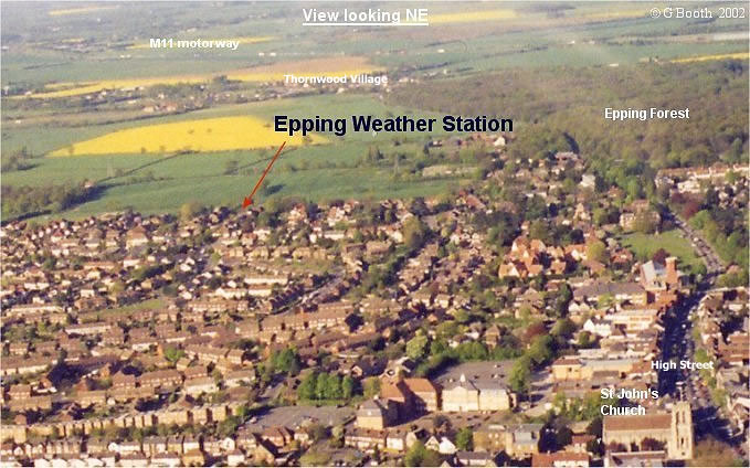
The Epping Weather Station is situated at 51° 42' 25" N, 0° 06' 55"E at a height of 107m (351') above sea level. The site lies at the northern end of the Epping Forest Ridge, a plateau-like area which reaches 117metres (384') above sea level just south of Epping. There are relatively steep slopes to the Roding Valley in the east and the Lea Valley in the west. The immediate geology consists of Eocene Claygate Beds (silty clays) overlain by Glacial Sands and Gravels and Boulder Clay. Most of the the area shown in the photograph is covered by Boulder Clay. The result is soils which are prone to waterlogging in winter and drying out in summer although this is not as marked as in the London Clay areas immediately to the south. Daily weather records have been kept continuously at the Epping Weather Station since January 1979. Maximum and minimum temperatures, relative humidity, rainfall, barometric pressure, wind direction and strength, cloud amount and weather for the previous 24 hours have been recorded every morning. Since October 2000 a Davis Automatic Weather Station has been added together with measurement of 20cm soil temperatures, grass minimum temperatures and sunshine hours. From 1979 the thermometers were housed in a Stevenson Screen but this was retired in 2003 for much needed refurbishment. From 2003 to 2010 the temperature and humidity sensors were housed in a Davis Radiation Shield. Eventually, in 2010, I tackled the task of creating a replacement Stevenson Screen from my original screen (purchased in 1960!) and one I had recently acquired from a gentleman in Bedford. Finally the sparkling new screen came into use in August 2010. Grass minimum temperatures are measured using a thermometer whose bulb is close to the tips of the grass. Rainfall is measured by a traditional rain gauge where it is measured every morning and a Davis Rain Collector which records continuously over a 24 hour period. The two instruments are used to ensure a degree of cross checking and accuracy. Sunshine hours are recorded using a RDInstromet sunshine recorder. Wind speed and direction are recorded by a Davis wind vane/anemometer which with the sunshine recorder is on a mast clear of the roof line. Barometric pressure is recorded on a Casella seven day barograph and by a sensor within the AWS monitor. In 2010 a Casella thermohygrograph was added to the instruments used. This records temperature and relative humidity as two traces on a chart which is on a 7 day rotating drum. The information from the Automatic Weather Station is displayed on monitors and processed by a PC using Weatherlink software before being transferred to Microsoft Excel. Data collected is supplied to a number of organisations-Climatological Observers Link (COL), the Weather Observers Network (WON) and Anglia Weather for publication in their monthly bulletins.
|
| Home | Site Map | The Weather Station | 2003 Weather Records |
2004 Weather Records |
2005 Weather Records |
2006 Weather Records |
2007 Weather Records |
2008 Weather Records |
2009 Weather Records |
2010 Weather Records |
1979-2010 Temperature | 1979-2010 Rainfall | 1979-2002 Daily Records | Useful Links | Weather Diary | Extremes |
| The
data on this website may be freely used for
personal
and/or academic purposes only -
please acknowledge source in
publication (amended January 2009) |
||||||||||||||||